Detailed Maps Classified In Belarus
4- 21.06.2023, 13:50
- 6,620
They showed more accurate details than the satellite images.
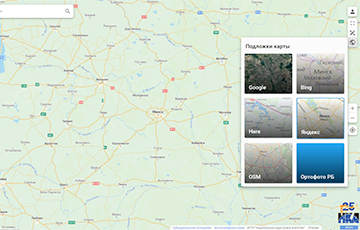
Republican Unitary Enterprise "National Cadastral Agency" has removed access to high-resolution aerial photography of Belarus - now these images cannot be seen by users, noted Flagshtok.
The page of the public cadastral map of Belarus used to contain a layer of aerial imagery, but now it is no longer available. According to the newspaper, access to the shots was removed about two days ago.
The orthophoto survey was created in Belarus until 2022. For some parts of the surface, the imagery contained the most up-to-date information compared to the imagery of online satellite imagery services.